The Murray River is one of the most renown riverine bioregions in Australia. It originates in the Australian highland region where a range of surface material is eroded and deposited in lower areas (Rutherford, 1990). This material includes sedimentary rock that originates from many years ago around the time of the Devonian period, when areas surrounding the present Murray course were inland sea, covered in marine waters (Rutherford, 1990, p22). This large amount of sedimentation (production and deposition) is one of the main causes for a range of features and formations we see in the Murray River floodplain.
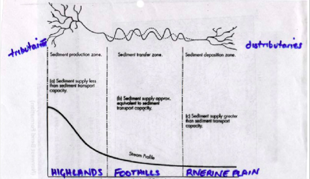
Figure A (Hodgson 2013)
Figure A shows a diagram of the three locational zones relevant to the Murray River and the relevant sedimentation process occurring in that zone. The highlands region (shown on the left in Figure A), which would include areas in the Alpine regions of Victoria and New South Wales, is called the ‘sediment production zone’ where small streams enter the main stream (called tributaries). In this zone sediment is being created and the flow of the river is faster, therefore transporting sediment at a quick rate. The second zone (shown in the middle in Figure A), called the foothills region, is the major area where sediment is transferred and the river velocity slows down. This is primarily where the river is known to meander, meaning that the river curves around creating a winding shape. The final zone, in the riverine plain (shown right in Figure A) is where the sediment supply is at its greatest and the river velocity is much slower. This creates the ‘sediment deposition zone’ where sediment is slowly washed up and the river branches out into slow moving distributaries or deltas.
Unlike youthful valleys that have steep gradients and swiftly flowing rivers, the Murray River floodplain could be likened to being a mature or old valley with a gentle gradient and slower velocity (Stone, 1974, p 62). It is a flat valley compared to other places in Australia or the world such as the Grand Canyon, which means that a lot of the surrounding area is well suited and currently used for farming (Stone, 1974, p 64). The slow moving river and sedimentary deposits in the old valley account for a range of features and formations on this website.
Unlike youthful valleys that have steep gradients and swiftly flowing rivers, the Murray River floodplain could be likened to being a mature or old valley with a gentle gradient and slower velocity (Stone, 1974, p 62). It is a flat valley compared to other places in Australia or the world such as the Grand Canyon, which means that a lot of the surrounding area is well suited and currently used for farming (Stone, 1974, p 64). The slow moving river and sedimentary deposits in the old valley account for a range of features and formations on this website.
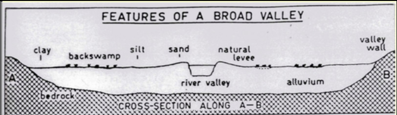
FIGURE B- transect of the river floodplain. (Hodgson, 2013)
Figure B shows a transect of the Murray floodplain. As shown, it stretches out for meters or kilometers past the river channel itself. The sides of the channel are known as 'levees' which is another name for the raised banks on the side of the river. There is a change of rock and sediment material as you move further away from the channel, such as changing from sands, to silt, to swampy area and then clay. This would influence a change in vegetation in the floodplain, from River Red Gums to Box trees to Saltbush in the outer parts of the valley.
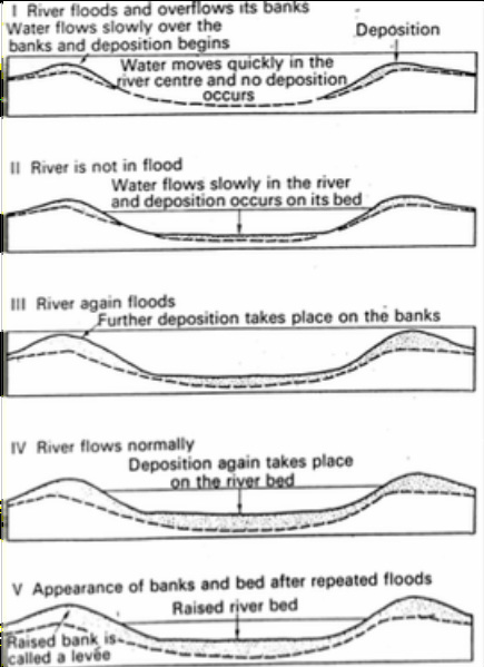
FIGURE C- how levees are formed. (Hodgson, 2013).
Figure C shows how sediment is deposited on the sides of river channels, forming levees. Levees are formed from a series of floods that bring up sediment from the river bed, which gets deposited on the banks by the water. These banks slowly increase in height after repeated flooding processes.
